The 2,200 km2 Tibooburra Gold Project comprises a land package covering ~220km of significantly under explored gold mineralised strike of deep-seated gold bearing structures associated with the Koonenberry and New Bendigo Regional Fault Structures within MHC’s 100% controlled tenure. The contiguous land package of eleven granted exploration licences and four exploration licence applications are located approximately 200km north of Broken Hill. The project stretches 160km south from the historic Tibooburra townsite and incorporates a large proportion of the Albert Goldfields, ), along the gold-anomalous New Bendigo Fault, to where it merges with the Koonenberry Fault, and then strikes further south on towards the recently discovered Kayrunnera gold nugget field. The area is conveniently accessed via the Silver City Highway, which runs N-S through the project area.
Project Highlights
District Scale 2,200 km2 strategic land holding in the emerging Koonenberry Gold District
220km gold strike extent
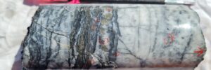
Mineralisation styles and structural development in the Tibooburra Goldfields are remarkably similar to the Victorian Goldfields in the Western Lachlan Orogen
Underexplored Goldfield with Multi – Million ounce potential
Drilling has intersected significant mineralisation – Best gold drill intersections reported from the Koonenberry region to date
Numerous historical shafts and historical mines and workings within MHC’s tenements have no drill testing
Southern targets contain an area of 80km of deep seated structured fault systems
Drill Programme
RC drilling was recently completed for 2,466m and continued to focus on extensions to the mineralised system and the interpreted north plunging shoots at depth and has continued to intersect significant shallow gold mineralisation within the corridor, often from or near surface. Further high-grade mineralised zones are thought to form two separate north plunging shoots located to the north and south of a cross-cutting fault. Further Drilling will continue to test the extents of the “Main Zone” mineralised system which has the potential to host a significant shallow, high-grade gold resource.
Diamond drilling was completed in July 2022 and intersected visible gold in diamond core that extends for ~20cm and is associated with laminated quartz veining within a broader altered interval. The program has focused on evaluating the higher-grade mineralisation that is interpreted to be associated with plunging veins and or shoots that have returned significant results.
Manhattan will now process core from diamond drilling, complete an evaluation of high grade structural core interpretation and complete additional drilling at Pioneer,
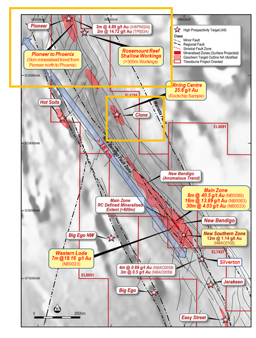
Reverce Circulation Drilling Results New Bendigo Main Zone
Drilling returned significant mineralisation and results support the interpretation of north plunging high grade shoots within a broader lower grade NNW trending regional shear “Mineralised Footprint including:
NB0089 8m @ 40.5 g/t Au from 70m, incl 3m at 105.34 g/t Au
NB0083 16m @ 13.89 g/t Au from 1m, incl 3m at 69.20 g/t Au
NB0088 7m @ 2.89 g/t Au from 56m, incl 1m at 15.45 g/t Au
NB0090 6m @ 1.93 g/t Au from 12m, incl 2m at 4.29 g/t Au
NB0081 3m at 4.67 g/t Au from 126m, incl 2m at 6.74 g/t Au
NB0093 17m @ 1.13 g/t Au from 4m incl 4m at 2.42 g/t Au from 6m
NB0106 3m @ 4.51 g/t Au from 9m
NB0110 3m @ 4.32g/t Au from 10m
NB0113 7m @ 13.10 g/t Au from 97m incl 5m at 18.01 g/t Au from 97m
NB0114 1m @ 11.10 g/t Au from 9m
NB0122 13m @ 6.16 g/t Au from 50m incl 3m at 25.48g/t Au from 51m
8m at 2.52/g/t Au from 70m Incl 1m at 17.85 g/t Au from 72m
Diamond Drilling Results
Significant Diamond Drilling results have returned:
NB0122 13m @ 6.16 g/t Au incl. 3m @ 25.48 g/t Au
NB01137m @ 13.10g/t Au incl 5m at 18.01 g/t Au
NB00897m @ 2.89 g/t Au incl 3m at 105.34 g/t Au
NB00836m @ 1.93 g/t Au incl 3m at 69.20g/t Au
NB0033 3m at 4.67 g/t Au incl 5m at 20.86 g/t Au
Diamond Drilling Core from the NBD0005 containing visible gold at approximately 97m depth
Further drilling
Manhattan will continue to target High Grade prospect areas along the northern 25km mineralised strike including:
New Bendigo Main Zone – recieved the gold drill intersections reported from the Koonenberry region to date
Western Lode – where RC drilling completed in 2020 returned 7m at 18.16 g/t Au from 87m (NB0023)
New Bendigo South – which lies ~ 600m on strike south of the “Main Zone” where scout drilling last year returned 12m at 1.14 g/t from surface (NBAC0103), intersecting a potentially new zone of gold mineralisation that is yet to be followed up
Northern Exploration Targets
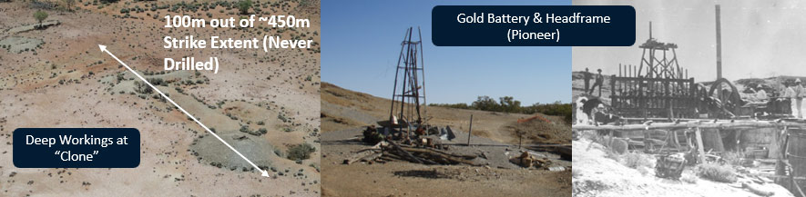
Pioneer
located ~18km north of the “Main Zone”
hosts historical gold workings over 5km of strike,
home to a historic gold stamping battery, where limited historic drilling returned 3m at 4.89 (AWNPN02A) and 2m at 14.72 (TP003A) g/t.
MHC have recently completed 4 RC holes for 732 metres – testing the system particularly at depth as well as a parallel lode that had not been previously drill tested
Drilling intercepted shale, with each hole hosting multiple zones of significant quartz-pyrite veining.
PN0002 5m at 6.96 g/t Au from 199m including:1m at 33.90 g/t Au from 199m
PN0001 2m at 1.66/g/t Au from 90m
PN003 3m at 1.28 g/t Au from 67m
Additional drilling to be completed at Pioneer on return of the remainder of results
Clone
Extensive deep historical gold workings over ~450m Strike and up to >25m deep)
Similar structural and lithological analogue to “Main Zone” at New Bendigo
Jeffery’s Flat
Located ~ 1,800 metres to the north of the Pioneer Mine
Hosts historic workings
MHC completed two (2) RC holes at Jeffery’s Flat (JF0001-02) for 330 metres
Drilling intercepted interbedded sandstone and siltstone units
Results pending
Elizabeth Reef
Untested smaller reef systems identified with no drill testing, including Rosemount (> 200m strike) and Elizabeth (NW of Pioneer – two historic reefs ~200m of strike)
Untested Southern Targets
Mongrel
8km of surface anomalism in limited geochemistry coinciding with multiple high priority intersecting structures over the extent of the anomaly and associated with quartz reefs and quartz veined hydrothermal breccias at surface
No drilling completed to date
Fold Nose
Series of Anticlinal fold closures with magnetic sediments, associated with and intersected by regional scale faults and shears
Demagnetisation evident within the closures, indicating a potential mineralising event (sulphidation)
Similar structural analogy to Sunrise Dam (>10Mozs Au) Laverton WA
Koonenberry & North Gap
Convergence and divergence of the main fault systems over ~20km
No systematic exploration completed to date, shallow workings present, sporadic rock chip sampling has returned up to 7.6 g/t Au
No drilling completed to date
Fault Spray
High Priority target where the deep-seated mantle tapping regional Koonenberry and New Bendigo faults converge
Untested large dilatational zones established that are favourable for gold accumulation
No drilling completed to date
Mining History
Auriferous quartz vein networks and alluvial deposits that shed from them, were mined in shallow pits, shafts and adits by early prospectors between 1881 and 1901. Over 1,700kg of gold was extracted, mostly from alluvial and eluvial deposits. Despite the rich rock-chip gold assays and overall historical mining grades of over 20g/t Au, the primary ore systems have rarely been tested below the water table (approx. 60m). Only sporadic exploration has been conducted since the abandonment of the goldfield in 1901, with undercover exploration utilising the high-quality geophysical datasets of the Geological Survey of NSW (”GSNSW”) now being possible.
Similarities to the Victorian Goldfields
After a detailed study of the Tibooburra District, GSNSW geoscientists (Greenfield and Reid, 2006) concluded that ‘mineralisation styles and structural development in the Tibooburra Goldfields are very similar to the Victorian Goldfields in the Western Lachlan Orogen’. In their detailed assessment and comparison, they highlighted similarities in the style of mineralisation, mineral associations, metal associations, hydrothermal alteration, structural setting, timing of metamorphism and the age of mineralisation, association with I-type
magmatism, and the character of the sedimentary host rocks. Mineralisation in the Tibooburra Goldfields is classified as orogenic gold and is typical of turbidite-hosted/slate-belt gold provinces (Greenfield and Reid, 2006).