Hook Lake Project
Nunavut, Canada
A High-Grade Gold Deposit that reports a “foreign” ³ non JORC Code compliant estimate of 3.4Mt @ 2.38g/t Au (~285,000 oz Au) tested only to shallow depths and open in all directions together with an adjacent polymetallic Copper, Zinc, Silver, Gold and Lead Project with previous diamond drilling delivering high grade VMS style mineralisation.
The Hook Lake Project is located in the same underexplored highly prospective Nunavut Archean Greenstone Belt that hosts significant gold mineralization discovered and developed to date, including Agnico Eagle’s 6.7moz Au Meladine Mine (34.3 million tonnes @ 6.12g/t Au¹) (130 to 225 km to the northeast of Hook Lake) and the in-development Back River Gold District, Goose & George Project boasting 9.2 Million Oz Au at 6.04g/t measured, indicated & Inferred with an anticipated 310,000 Ozs Au annual production – B2Gold, 2024².
The Project comprises nine separate prospects (within three mineral claims and exploration agreements), covering a total of 423 km² within the Rankin-Ennadai greenstone belt.
The most advanced target within the project is the Jaws (formerly Turquetil Lake) gold deposit, which was predominantly diamond drilling in the late 1980s, lies within the furthest southwest block of claims/exploration agreements.
¹ Agnico Eagle, 2015 – Updated Technical Report on the Meliadine Gold Project, Nunavut, Canada by Julie Larouche, Denis Caron, Larry Connell, Dany Laflamme, François Robichaud, François Petrucci & Alexandre Proulx. February 11, 2015.
² B2Gold, 2024 Reserves & Resources Statement: https://www.b2gold.com/operations-projects/overview/default.aspx#probable

Hook Lake Project Location & Nearby Major Mines
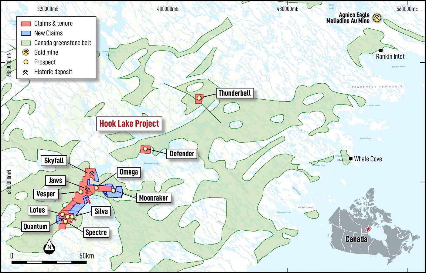
Hook Lake Prospect Locations and Nearby Meliadine Gold Mine operated by Agnico Eagle
Hook Lake Maiden Exploration Programme – July 2025
The Hook Lake Prospect has remained largely dormant since 1988 when drilling activities defined a significant gold occurrence that remains open in all directions.
Exceptional exploration upside exists at the Project with exploration to initially focus on the:
Jaws (formerly Turquetil Lake) Deposit, a High-Grade Gold Deposit that reports a “foreign” 3 non JORC Code compliant estimate of 3.4Mt @ 2.38g/t Au (~285,000 oz Au) over a 940m strike length, and remains open in all directions, including down plunge & dip, with previous drill testing only to a maximum of ~190 m vertical depth. Drilling completed to date has returned significant gold intercepts, including but not limited to TAU-76-01: 27.58m @ 3.33g/t Au from 44.35m, including 13.01m @ 6.29g/t Au from 53.04m, 133-88-25: 15.2m @ 4.50g/t Au from 14.70m, 133-88-02: 52.78m @ 3.38g/t Au from 89.22m, including 46.22m @ 3.80g/t Au from 89.78m, 133-88-04: 16.0m @ 5.04g/t Au from 52.0m
Spectre (formerly Heninga Lake) Prospect is a VMS system, with drilling returning GMX-01: 10.51m @ 2.91% Cu, 6.70% Zn, 95.67g/t Ag, 1.04 g/t Au & 0.48% pb from 41.76m, GMX-02: 13.71m @ 1.51% Cu, 2.06% Zn, 47.23g/t Ag 0.56g/t Au & 0.09% Pb from 70.26m.
Jaws, High-Grade Gold Prospect
The Jaws Gold Deposit is situated in the Archean Rankin Inlet-Ennadai greenstone belt of the Hearne Structural Province approximately 225 km southwest of Rankin Inlet where the gold producing Meliadine Complex of Agnico Eagle is located. Lithologies consist of mafic, intermediate, felsic volcanic rocks, along with metasedimentary units that include banded iron formations (BIF).
Three Archean batholiths bound these formations with three steeply-dipping regional shear zones transecting the prospect. The Jaws Shear Zone (TLSZ) the Skyfall (formerly Spi Lake) Shear Zone (SLSZ), and the Jaw Lake Shear Zone (JLSZ), which all trend northeast.
Gold was discovered in 1948 during reconnaissance exploration, this was later followed up in 1976 with one drill hole (TAU-76-1) for 84.4 metres being completed by Essex (Essex) Mineral Company Ltd (Robinson, et al, 1988). A further 6 Holes (TAU-78-1 to 06) were completed by Essex in 1978.
To date Manhattan has only located the logs for the first three holes drilled by Essex (TAU-78-1 to 3). Drilling returned peak results (Robinson, et al, 1988), including:
- 27.58m @ 3.33g/t Au from 44.35m, including 13.01m @ 6.29g/t Au from 53.04m
- 17.99m @ 2.09g/t Au from 85.95m
The main phase of exploration occurred in 1988, when 66 diamond holes (133-88 series prefix 01-64, 04A & 54A) were completed by Dejour Mines Ltd & Noble Peak Resources for ~10,620m (Robinson, et al, 1988, Table 1 – Appendix 2) alongside airborne electromagnetic surveys and magnetic surveys.
Drilling returned significant results (Compiled data from Robinson, et al, 1988), with selective results including:
- 52.78m @ 3.38g/t Au from 89.22m, including 46.22m @ 3.80g/t Au from 89.78m
- 16.0m @ 5.04g/t Au from 52.0m
- 40.2m @ 1.74g/t Au from 87.80m, including 30.5m @ 2.17g/t Au from 97.5m
- 15.2m @ 4.50g/t Au from 14.70m
- 27.4m @ 3.39g/t Au from 124.0m & 18.4 @ 1.53g/t Au from 172.5m @ 2.17g/t Au from 180m, including 10.10m @ 2.44g/t Au from 180.4m
- 13.95m @ 1.48g/t Au from 39.9m & 9.5m @ 8.31g/t Au from 273m
- 45.35m @ 2.15g/t Au from 139.8m
- 45.0m @ 2.46 g/t Au from 138.5m, including 10.5m @ 5.45g/t Au from 138.5m
- 53.25m @ 2.87g/t Au, including 26.05m @ 4.79g/t Au from 168.5m
Drilling to date confirmed two main gold bearing zones (“Main” & “Southern” Lodes) that occur over approximately 1,600 metres of strike and are separated by an untested (drill) gap of approximately 540 metres, demonstrating that significant upside remains within the prospect firstly by infilling the identified gap and further testing strike extensions to the NE & SW as evident by the last line of drilling completed and compiled by Manhattan to the northeast returning:
- 13.2m @ 1.47g/t Au from 24.8m, including 7.2m @ 2.24g/t Au from 24.8m
- 3.1m @ 2.90g/t Au from 137m
- 4.75m @ 1.17g/t Au from 63m
- 6.0m @ 1.03g/t Au from 19m
With one hole drilled on the last line of drilling to the southwest (OmniX, 2025) returning:
- 3.7m @ 3.29g/t Au from 85.9m
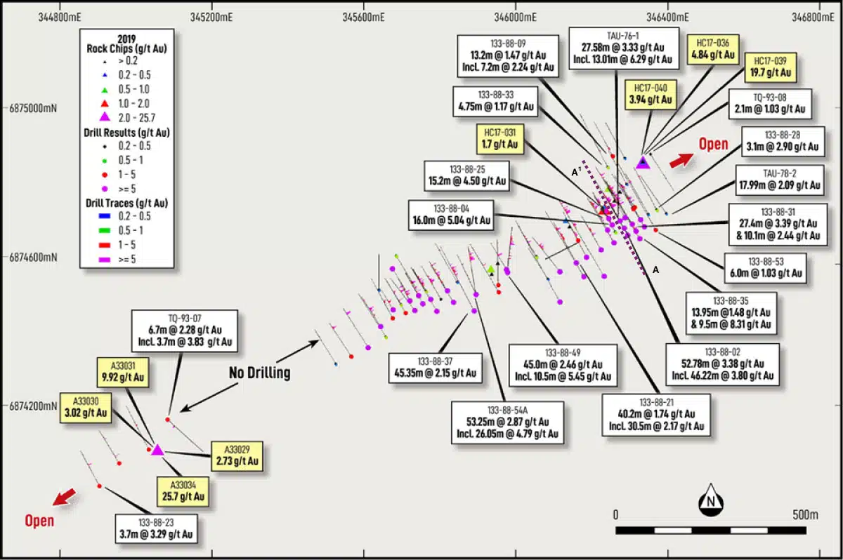
Jaws Au Occurrence, showing drill hole collar locations and grade with selective downhole intervals. Also shown are Rock Chip Samples > 1 /gt Au
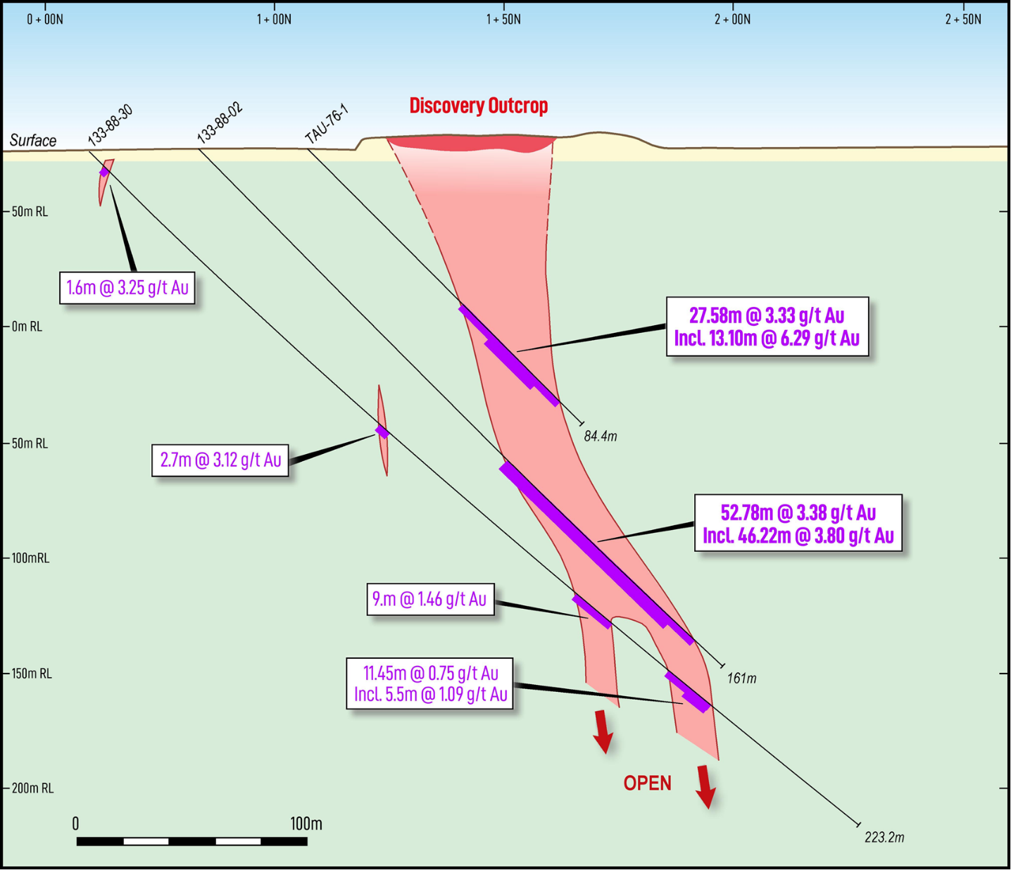
Jaws Drillhole Section A-A1 (as marked on previous figure)
Placer Dome Inc. optioned into the project in 1991, completing a further eight (8) diamond holes (TQ-93-01 to TQ-93-08) for ~1,014 metres in 1993 (Stroshein, 1994). Two holes were completed on the Jaws zone (TQ-93-07 to 08). Hole TQ-93-07 was completed ~90m NE of the eastern most hole on the Southern Lode, returning 6.7m @ 2.28g/t Au from 32m, including 3.7m @ 3.83g/t Au from 35m.
Whilst hole TQ-93-08 was drilled ~60m NE of the eastern most hole on the main Lode returning a peak result of 2.10m @ 1.03g/t Au from 33.4m. The placement of the hole and the change in azimuth (drilled grid south as opposed to grid north) is considered by Manhattan to not be an effective test of the continuance of mineralisation to the NE, or to capture mineralisation identified in Rock Chip sampling completed in 2017 by Mr John Tugak (See below).
The remaining Six diamond holes (TQ-93-01 to TQ-93-06) were drilled on magnetic anomalies predominantly SW of the Jaws occurrence and returned no significant mineralisation.
Mineralisation has also been identified outside of the main drilled areas, firstly by Mr Tugak, who conducted rock chip sampling in 2017 of quartz veins and alteration zones (Tugak, 2017). Mr Tugak identified significant upside remains with rockchip sampling returning up to 19.7g/t Au located ~225m NNE (Sample HC17-039) of the main lode drilling, indicating potential extensions to the NNE or NE of the known drill tested gold mineralisation.
Further sampling by Placer Dome Inc. in 1991, identified further gold mineralisation in the Jaws area, notably sample A33034 notably returning 25.7g/t Au near the NE extent of the southern lode (Sterenberg VZ. & Martin LS).
2017 Rock Chip Sampling Locations and Au Grade
|
Sample Id |
East |
North |
Au |
Sample Id |
East |
North |
Au |
|
HC17-020 |
346,709 |
6,874,092 |
0.09 |
HC17-031 |
346,233 |
6,874,731 |
1.70 |
|
HC17-021 |
345,974 |
6,874,448 |
0.00 |
HC17-032 |
346,244 |
6,874,786 |
0.69 |
|
HC17-022 |
345,934 |
6,874,570 |
0.79 |
HC17-033 |
346,259 |
6,874,752 |
0.19 |
|
HC17-023 |
345,952 |
6,874,584 |
0.03 |
HC17-034 |
346,273 |
6,874,776 |
0.01 |
|
HC17-024 |
345,936 |
6,874,555 |
0.01 |
HC17-035 |
346,335 |
6,874,857 |
9.60 |
|
HC17-025 |
346,131 |
6,874,699 |
0.23 |
HC17-036 |
346,334 |
6,874,857 |
4.84 |
|
HC17-026 |
346,141 |
6,874,682 |
0.02 |
HC17-037 |
346,334 |
6,874,857 |
0.39 |
|
HC17-027 |
346,141 |
6,874,682 |
0.05 |
HC17-038 |
346,334 |
6,874,857 |
0.19 |
|
HC17-028 |
346,141 |
6,874,682 |
0.04 |
HC17-039 |
346,334 |
6,874,852 |
19.70 |
|
HC17-029 |
346,227 |
6,874,733 |
0.02 |
HC17-040 |
346,334 |
6,874,857 |
3.94 |
|
HC17-030 |
346,232 |
6,874,734 |
0.41 |
Jaws 1991 Placer Dome Rock Chip Sampling Locations & Assays
|
Prospect |
Sample Id |
East |
North |
Au |
Ag |
Cu |
Pb |
Zn |
| Jaws |
A33029 |
345045.2 |
6874080 |
2.73 |
0.20 |
2 |
55 |
2 |
|
A33030 |
345045.2 |
6874080 |
3.02 |
0.20 |
5 |
49 |
5 |
|
|
A33031 |
345045.2 |
6874080 |
9.92 |
1.00 |
15 |
2,016 |
15 |
|
|
A33032 |
345045.2 |
6874080 |
0.66 |
0.20 |
5 |
47 |
5 |
|
|
A33033 |
345045.2 |
6874080 |
0.46 |
0.20 |
1 |
57 |
1 |
|
|
A33034 |
345045.2 |
6874080 |
25.70 |
0.70 |
1 |
84 |
1 |
|
|
A33035 |
345045.2 |
6874080 |
0.07 |
0.10 |
1 |
53 |
1 |
|
|
A33109 |
361952.9 |
6875306 |
1.01 |
240.00 |
3,200 |
8,500 |
3,200 |
|
|
A33110 |
361952.9 |
6875306 |
0.33 |
600.00 |
12,200 |
27,000 |
12,200 |
|
|
A33111 |
361952.9 |
6875306 |
0.32 |
6.00 |
654 |
654 |
654 |
|
|
A33129 |
363757 |
6874430 |
0.19 |
1.50 |
193 |
311 |
193 |
|
|
A33130 |
363748.5 |
6874482 |
5.80 |
3.40 |
136 |
220 |
136 |
|
| Jaws NE |
A33265 |
348105.8 |
6877231 |
0.00 |
0.05 |
6 |
60 |
6 |
| Jaws SW |
A33028 |
344785.4 |
6873892 |
0.00 |
0.40 |
5 |
1094 |
5 |
The Project area is also host to both out cropping and sub-cropping BIF which exhibits structural disruption and folding. The BIF has been historically noted as a target for further gold mineralisation, however, has never been tested due to cover. Of a high priority is the Omega (formerly Red Flats) target, (Refer Section Moonraker (formerly Seahorse Lake) & Omega Prospect) 6 km ENE of the Jaws deposit that presents as a magnetic high with obvious cross-cutting structures, offering a fluid pathway into the reactive BIF.
³ Foreign Estimate
The Jaws Prospect reports a foreign non JORC Code compliant estimate of 3.4Mt @ 2.38g/t Au (~285,000 oz Au) over a 940m strike length, and remains open in all directions, including down plunge & dip, with previous drill testing only to a maximum of ~190 m vertical depth.
On completion of drilling in 1988, Derry, Michener, Booth & Wahl (Derry) a Toronto based consultancy at the time was contracted in 1990 to complete a resource estimate on the Jaws property.
A 1990 report by Derry, Michener Booth and Wahl contains grade and tonnage estimates of the Jaws deposit. A total probable reserve of 3,393,713 tonnes grading 2.38g/t was outlined in the report (MH Resources, 1994). No methodology or criteria has been referenced in the report for the “Foreign” estimate.
The Company notes that the Resource estimate quoted for Jaws is considered to be a “Foreign” estimate and is not reported in accordance with the JORC Code or previous iterations of acceptable reporting codes.
Relevant information in relation to the work program, methodology, summary of key material assumptions and parameters utilised to calculate the estimate is not available to the Company at this time and the Company has relied on extracts from published reports in quoting the estimate.
A competent person has not done sufficient work to classify the “Foreign” estimate as Exploration Results or Mineral Resources or Ore Reserves in accordance with the JORC Code. There are no more recent estimates available. It is uncertain that, following further evaluation and/or further work that the historical estimates will be able to be reported in accordance with the JORC Code (2012). The “Foreign” estimate is relevant and material to Manhattan’s proposed acquisition of the Project via the Proposed Transaction as it represents significant targets for possible definition of JORC Code compliant results.
Further to this, Omni GeoX (2025) and the Company have reviewed the available data and consider the “Foreign” Estimate to be a fair and reasonable representation of the data and that the Company has in its possession information regarding the lab techniques, density measurements and assumed processing & metallurgy for the 1988 drilling which would have contributed to the estimate.
Spectre (formerly Heninga Lake), Silva (formerly Mag Lake) & Skyfall (formerly Spi Lake) VMS Prospects
The Spectre & Skyfall Prospects are located ~28 km SSW & ~13 km NNE respectively of the Jaws Au occurrence. VMS potential within the Project area was first identified by Hudson Bay Mining and Smelting Corp. in 1948 with the discovery of a gossan within the area.
Spectre Prospect
The Spectre Prospect was first drilled in 1948 by Hudson Bay Mining & Smelter Co, with further drilling completed by Gemex Minerals Inc. (Gemex) in 1974 and by St Joseph Minerals (1976-81).
Gemex completed six diamond holes for ~582 metres in 1974 with drilling intersecting discordant stringers (interpreted as part of a feeder system) and semi-massive to massive sulphides comprised of chalcopyrite, pyrite, sphalerite and minor pyrrhotite consistent with VMS hosted mineralisation. Drilling returned significant mineralised intersections (Skimming, 1975), including:
- 10.51m @ 2.91% Cu, 6.70% Zn, 95.67g/t Ag, 1.04g/t Au & 0.48% pb from 41.76m
- 30.63m @ 0.24% Cu, 0.52% Zn, 6.51g/t Ag 0.04 g/t Au & 0.01% Pb from 38.71m. Plus 13.71m @ 1.51% Cu, 2.06% Zn, 47.23 g/t Ag 0.56g/t Au & 0.09% Pb from 70.26m
- 12.19m @ 0.38% Cu, 0.17% Zn, 4.74g/t Ag 0.05 g/t Au & 0.01% Pb from 37.49m. Plus 7.62m @ 0.78% Cu, 0.07 % Zn, 13.90 g/t Ag 0.05 g/t Au & 0.01% Pb from 72.85m
- 34.29m @ 0.64% Cu, 2.39% Zn, 41.96 g/t Ag 0.09 g/t Au & 0.18% Pb from 58.379m
The Company notes that the Exploration Results quoted above are historical and are not reported in accordance with the JORC Code (2012). A competent person has not done sufficient work to verify these historical Exploration Results in accordance with the JORC Code.
Silva Prospect
A further zone of VMS prospective ground is located at Silva to the NE of Spectre Prospect & 6km NE of Spectre. It is interpreted that the two zones (Spectre & Silva) are connected by the same volcanic-sedimentary horizons. Multiple historic surface mineral occurrences have been identified at Silva and are reported to be of a similar composition to Spectre. Exploration completed in the area has identified numerous base metal and gold showings, including:
- Silva Occurrence consists of polymetallic sulphide zone that extends for ~120m comprising massive sphalerite, chalcopyrite and galena. Rock samples from this occurrence have returned assays of up to 36% Zn & 2.5% Cu associated with significant Au & Ag (MH Resources, 1994)
- Conformable quartz-carbonate vein (~0.4 m wide and at > 150m long) that contains up to 10% pyrite, 2% chalcopyrite. Chip sampling (across the vein) has returned assays of up to 11.31 g/t Au, 1,248.7 g/t Ag. 0.63% Cu and 0.13% Pb over 0.30m. A previous sample across the vein assayed 100 g/t Au, 5,567.7 g/t Ag, 0.36% Cu, 0.3% Zn $ 1.81% Pb over 0.7m (MH Resources, 1994)
The Company notes that the Exploration Results quoted above are historical and are not reported in accordance with the JORC Code (2012). A competent person has not done sufficient work to verify these historical Exploration Results in accordance with the JORC Code
Skyfall Prospect
The Skyfall Prospect is 11.1km north of the Jaws Prospect. The Prospect represents an underexplored VMS showing similar in nature to Spectre. Skyfall comprises chlorite-biotite-talc alteration hosted within felsic volcanoclastic rocks.
Giant Yellowknife Mines (Yellowknife) identified the Prospect in 1960, Yellowknife described outcrops of zinc & copper mineralisation (R.V Beavon et al, 1973), identifying sulphide mineralisation at surface, notably chalcopyrite-galena-sphalerite-pyrite-pyrrhotite.
Moonraker (formerly Seahorse Lake) & Omega (formerly Red Flats) Prospects
The Moonraker & Omega Prospects are located to the east of the Jaws Prospect and host significant exploration prospectivity.
Omega hosts a significant Banded Iron Formation (BIF) with significant mineralisation potential, Whilst Moonraker has undergone rockchip sampling that has returned up to 5.8 g/t Au over 2km of strike.
Moonraker Prospect
Moonraker is located 16km east of the Jaws Prospect. Placer Dome undertook Rockchip sampling in 1991 over approximately 2km of strike. Sampling returned Au values of up to 5.8g/t Au (A33130) (Sterenberg, 1992). Sampling also identified polymetallic potential with the return of 740g/t Ag (A33105), 0.36% Cu (A33110), 1.34% Pb and 2.8% Zn (A32535) (Sterenberg, 1992).
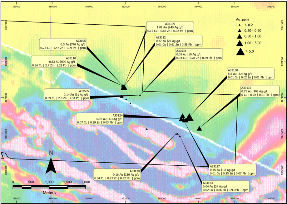
Moonraker Au Occurrence, Placer Dome Rock Chip Sampling (low resolution aeromagnetic survey background image, vertical derivative)
Moonraker 1991 Placer Dome Rock Chip Sampling Locations & Assays
|
Prospect |
Sample Id |
East |
North |
Au |
Ag |
Cu |
Pb |
Zn |
| Moonraker |
A32534 |
362392.4 |
6875072 |
0.05 |
10.00 |
3900 |
17,800 |
3,900 |
| Moonraker |
A32535 |
362392.4 |
6875072 |
0.15 |
31.00 |
13400 |
28,000 |
13,400 |
| Moonraker |
A32813 |
355876 |
6875064 |
0.00 |
0.10 |
7 |
15 |
7 |
| Moonraker |
A33105 |
361919.2 |
6875334 |
0.30 |
740.00 |
10,900 |
14,700 |
10,900 |
| Moonraker |
A33106 |
361960.1 |
6875333 |
0.15 |
4.30 |
245 |
567 |
245 |
| Moonraker |
A33108 |
361952.9 |
6875306 |
0.10 |
0.50 |
16 |
82 |
16 |
| Moonraker |
A33112 |
361952.9 |
6875306 |
0.27 |
25.00 |
5,800 |
6,100 |
5,800 |
| Moonraker |
A33113 |
361952.9 |
6875306 |
0.03 |
0.90 |
65 |
187 |
65 |
| Moonraker |
A33119 |
362579.8 |
6874143 |
0.11 |
0.40 |
37 |
47 |
37 |
| Moonraker |
A33120 |
363385.6 |
6874012 |
0.16 |
130.00 |
9,200 |
2,700 |
9,200 |
| Moonraker |
A33121 |
363429.9 |
6874011 |
0.02 |
1.10 |
92 |
1,237 |
92 |
| Moonraker |
A33122 |
363487.9 |
6873947 |
0.03 |
1.20 |
252 |
925 |
252 |
| Moonraker |
A33123 |
363487.9 |
6873947 |
0.04 |
24.00 |
9,300 |
8,600 |
9,300 |
| Moonraker |
A33124 |
363530.4 |
6874426 |
0.97 |
4.30 |
323 |
3,900 |
323 |
| Moonraker |
A33125 |
363590.9 |
6874422 |
0.25 |
2.00 |
179 |
87 |
179 |
| Moonraker |
A33126 |
363530.4 |
6874426 |
0.84 |
1.10 |
59 |
28 |
59 |
| Moonraker |
A33127 |
363590.9 |
6874385 |
0.45 |
1.80 |
719 |
3,500 |
719 |
| Moonraker |
A33128 |
363654.8 |
6874393 |
0.92 |
1.90 |
40 |
53 |
40 |
| Moonraker |
A33131 |
363564.5 |
6874515 |
0.62 |
0.80 |
21 |
14 |
21 |
| Moonraker |
A33132 |
364025.8 |
6874166 |
0.75 |
303.00 |
103 |
7 |
103 |
| Moonraker |
A33300 |
361891.6 |
6875050 |
0.35 |
0.30 |
24 |
97 |
24 |
| Moonraker |
A33301 |
362014.2 |
6874963 |
0.02 |
0.10 |
20 |
120 |
20 |
| Moonraker |
A33302 |
362128.4 |
6874852 |
0.05 |
0.05 |
23 |
98 |
23 |
The Company notes that the Exploration Results quoted above are historical and are not reported in accordance with the JORC Code (2012). A competent person has not done sufficient work to verify these historical Exploration Results in accordance with the JORC Code.
Omega Prospect
The Omega Prospect is located between Moonraker & the Jaws Gold Prospect.
Omega hosts a significant deformed and faulted BIF visible for over 7km in regional magnetic datasets with interpreted BIF aligning with historic IP and EM. The area remains untested by drilling to date.
Shear hosted Banded Iron Formation’s (BIF’s) are a major contributor to defined gold deposits in Nunavut and Archean Greenstone belts globally.
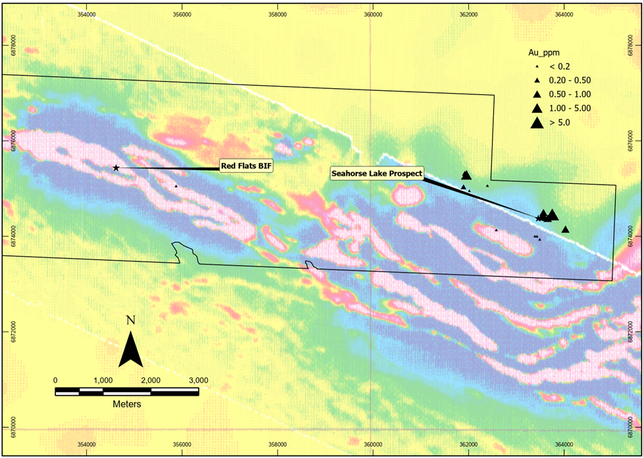
Omega prospective BIF’s seen as high magnetic response (pink & white colouring in low resolution aeromagnetic survey background image, vertical derivative)
Quantum and Lotus
Quantum and Lotus have never been drill tested. They represent further “Jaws-style” orogenic/greenstone gold targets with high-grade gold-silver assay results from the maiden surface sampling programme. Both targets have exposed quartz veins at surface which are conformable to the NE/SW trend of local stratigraphy in the Archean volcanics. The veining is covered at both ends by a veneer of glacial overburden, but they are sampled over strike lengths of 67m (quantum) and 66m (lotus) by maiden sampling efforts. As both vein systems are untested by drilling there is strong upside for discovery potential. The 2025 magnetic survey will assist in drill targeting these well-endowed systems.
Quantum assay highlights:
- 16.75g/t Au & 385g/t Ag (M209533)
- 14.05g/t Au, 1385g/t Ag, 0.32% Cu (M209538)
- 11.2g/t Au, 1485g/t Ag, 0.47% Cu (M209537)
- 10.65g/t Au & 107g/t Ag (M209539)
- 7.13g/t Au & 67.8g/t Ag (M209535)
- 4.15g/t Au & 90.6g/t Ag (M209534)
- 2.31g/t Au & 86.7g/t Ag (M209536)
At Quantum, a further set of subcrop rock samples were taken to the west, where precious metal values were lower, but samples returned elevated base metals. Sample M209530, a quartz-carbonate veined, chlorite altered mafic volcanic returned 0.699% Cu, 0.125% Co. Samples M209529 and M209531 returned 0.257% and 0.146% Cu respectively.
Lotus assay highlights:
- 8.01g/t Au & 2660g/t Ag (M209523)
- 3.8g/t Au & 761g/t Ag (M209522)
- 2.46g/t Au & 273g/t Ag (M209524)
- 1.13g/t Au & 194g/t Ag (M209525)
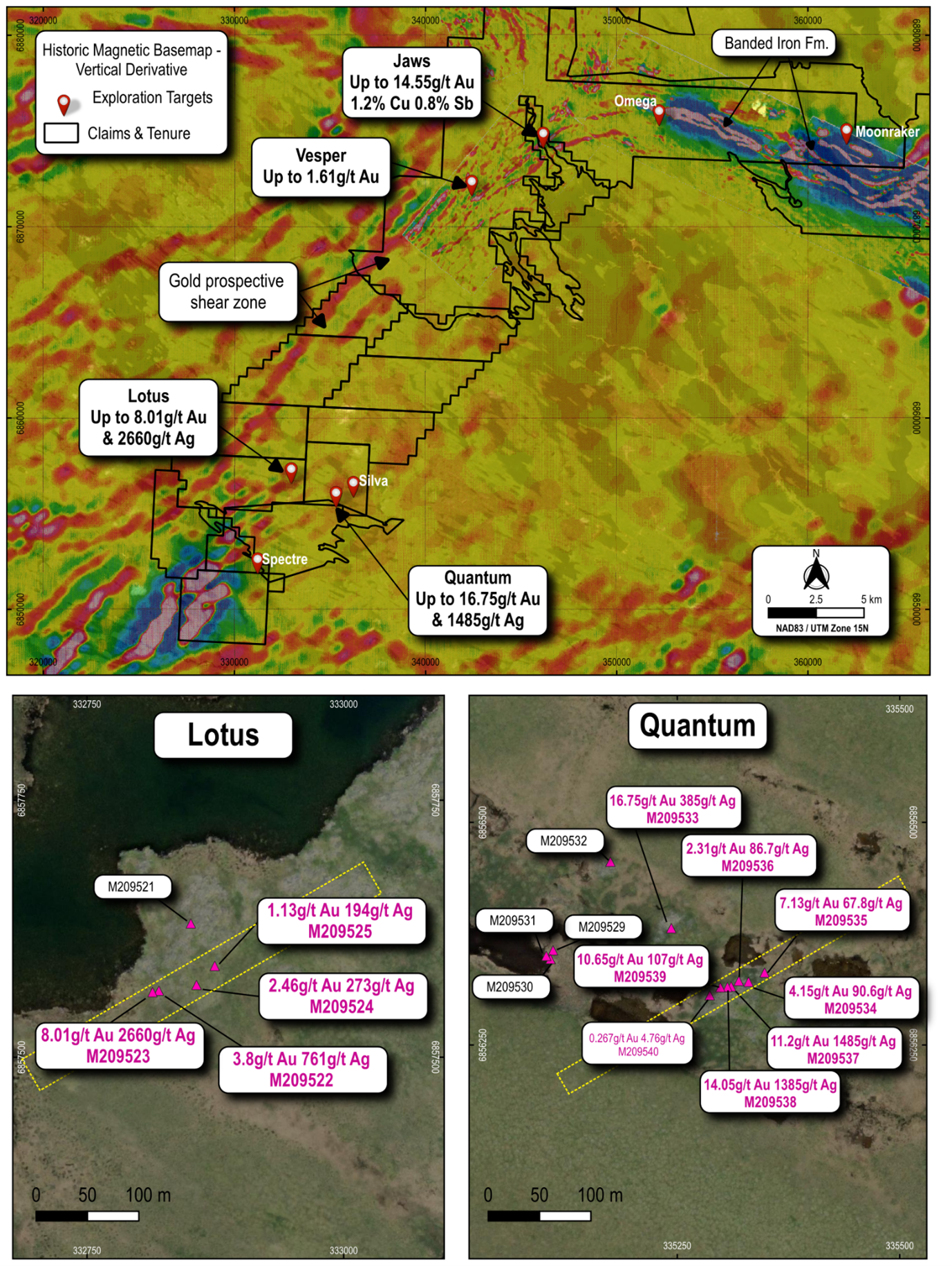
Lotus and Quantum sample locations, within context of broader project area including Jaws and Vesper
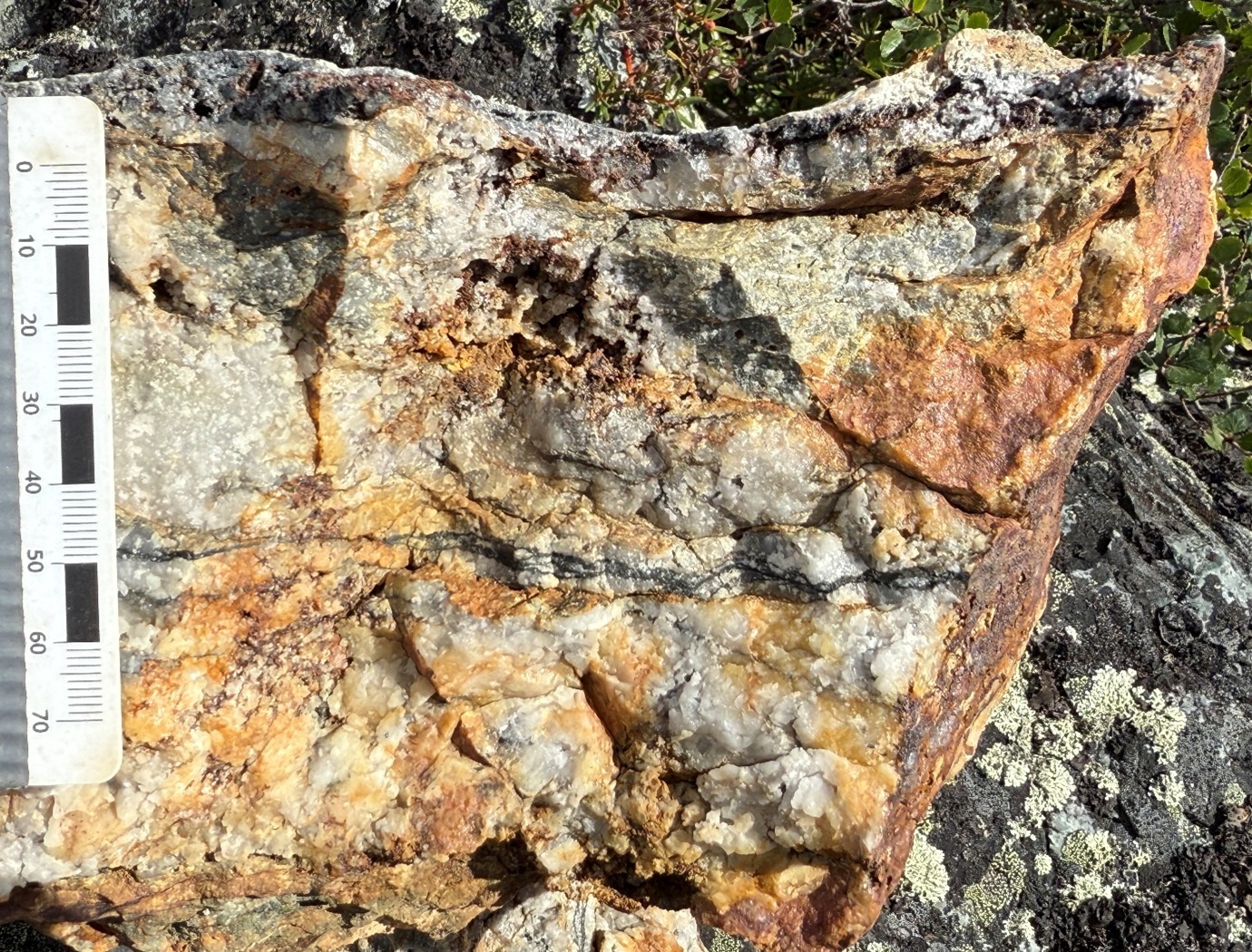
Rock sample M209533 quartz vein from the Quantum target area. Sample returned 16.75g/t Au and 385g/t Ag.
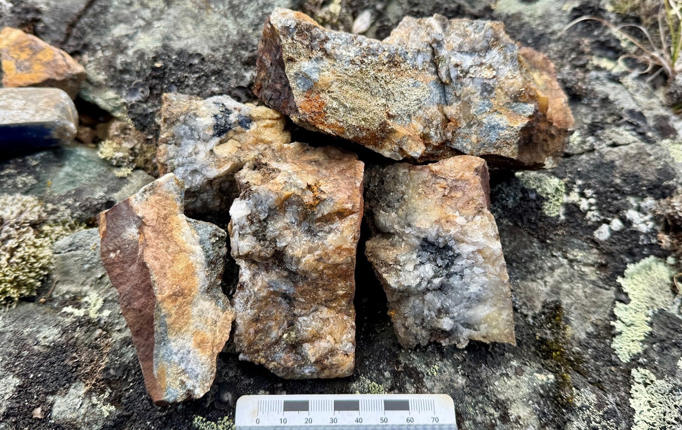
Rock sample M209538 from the Quantum target area. Sample returned 14.05g/t Au, 1385g/t Ag, 0.32% Cu.
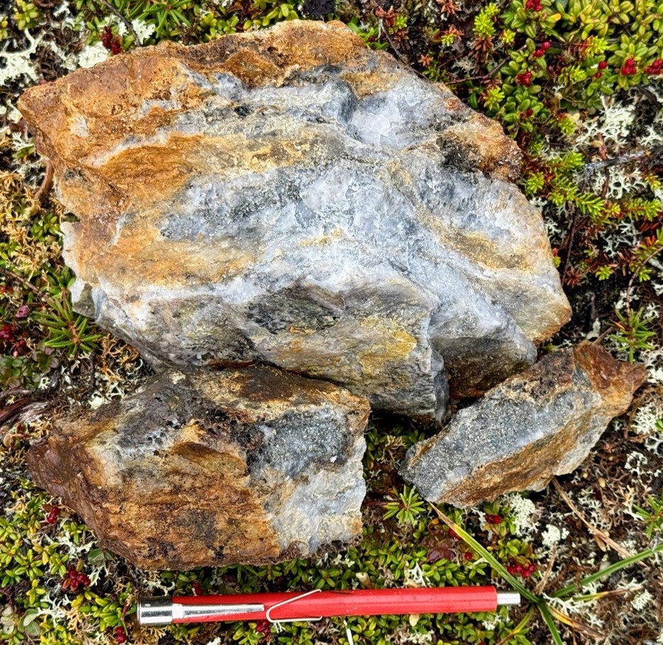
Rock sample M209523 from the Lotus target area. Sample returned 8.01g/t Au & 2660g/t Ag.
Rock sample location M209522 and NE trend outlined by white dashed lines towards NE and direction of further samples M209523-M209525. Sample M209522, taken from the outcrop pictured returned 3.8g/t Au & 761g/t Ag.
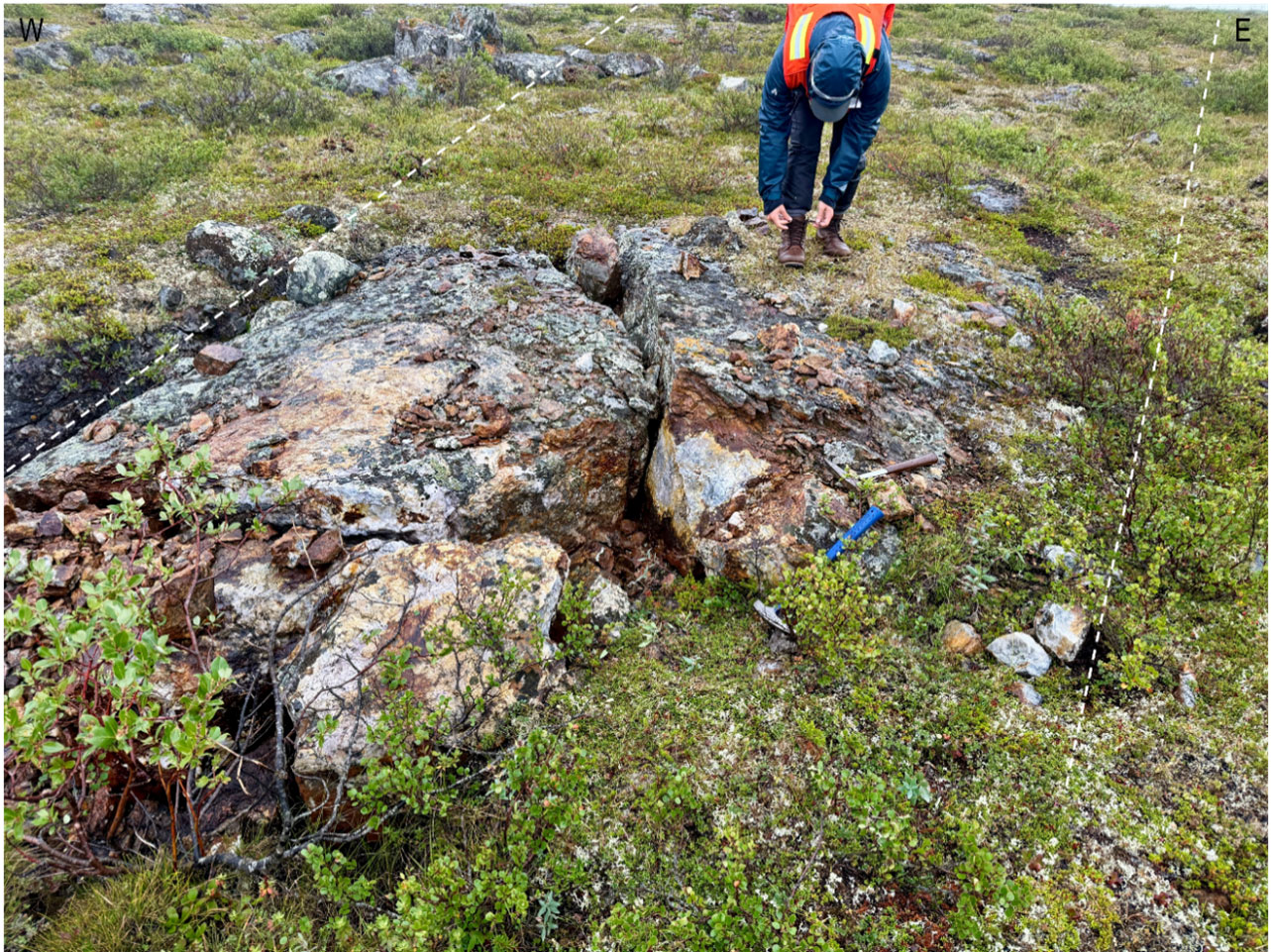
Defender (formerly VG) Prospect – Orogenic Gold
The Defender Prospect is located 50km NE along the greenstone belt from Jaws Prospect. The prospect is relatively underexplored and has undergone mapping, geophysical surveys, rockchip sampling, trenching and drilling.
A narrow zone of quartz veining and shearing occurs within and near the top of a sequence of pillowed and massive mafic volcanic flows, which are overlain by an exhalative zone (banded and brecciated iron formation & sulphidic iron formation). Visible gold was found with rock chip sampling of surface exposures returning up to 709.7 g/t Au (Sample ID 91151 – 386,200E 6,902,836N NAD83 Zone 15N) by Sikaman Reources, (Sikaman, 1989).
¹ Sample No. 9115, was analysed by Barringer Laboratories (Toronto Canada Job # 891200) by Screen Fire Assay utilising Fire Assay (Atomic Absorption). Analysis by Barringer returned 20.7 oz/t (709.7 g/t) Au. No information has been obtained or is available in regards to the appropriateness of the sampling method, though Manhattan has included as it feels that it is material to the mineralisation style being sort by Manhattan at the Defender Prospect.
To date, 27 drill holes have been located within the prospect area for 1,684m, with the holes yet to be compiled and verified from historic logs. Drilling was completed over a period spanning 1988 to 1989, with the holes and their associated assay data yet to be compiled and verified from historic logs.
Drilling, and other exploration works completed in the area has not yet been completely compiled or verified by Manhattan, with ground proofing required to verify the precise locations of localised grids.
The Company notes that the Exploration Results quoted above are historical and are not reported in accordance with the JORC Code (2012). A competent person has not done sufficient work to verify these historical Exploration Results in accordance with the JORC Code.
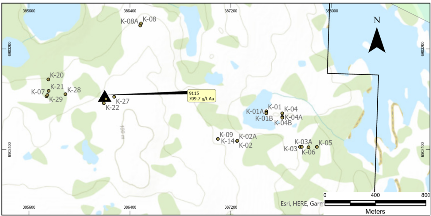
Defender Prospect Location Map Known Drill Hole Collars & Sample 9115 (NAD83 Zone 15N)
Spook Prospect – Orogenic Gold
The Spook Prospect is located NE along the greenstone belt from Jaws towards the Meliadine Au Mine of Agnico Eagle. Exploration completed at Spook by Noble Peak Resources Inc from 1987 to 1988 (Noble, 1988) identified 10 ten zones of gold and base metal mineralization within an outlined 2km x 2km area. Mineralization is associated with quartz veining within interflow chemical sediment and tuffaceous units. Visible gold is noted to have been panned from trench and rubble material at Spook.
Drilling, and other exploration works completed at Spook, has not been compiled or verified by Manhattan, with ground proofing required to verify the precise locations of localised grids.
The Company notes that the Exploration Results quoted above are historical and are not reported in accordance with the JORC Code (2012). A competent person has not done sufficient work to verify these historical Exploration Results in accordance with the JORC Code.